Wednesday, April 24, 2024 | St. Lawrence County, NY
LOUISVILLE -- North Country Assemblywoman Addie A.E. Jenne, D-Theresa, says she is concerned by the impact the International Joint Commission's decision to keep outflows high this summer is having on …
This item is available in full to subscribers.
To continue reading, you will need to either log in to your subscriber account, or purchase a new subscription.
If you are a digital subscriber with an active, online-only subscription then you already have an account here. Just reset your password if you've not yet logged in to your account on this new site.
Otherwise, click here to view your options for subscribing.
Please log in to continue |
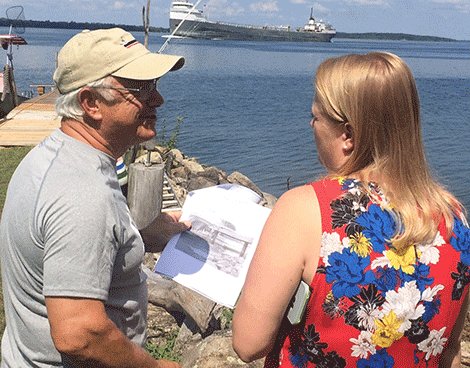
LOUISVILLE -- North Country Assemblywoman Addie A.E. Jenne, D-Theresa, says she is concerned by the impact the International Joint Commission's decision to keep outflows high this summer is having on the Lake St. Lawrence shoreline in St. Lawrence County.
Jenne toured the shoreline on Wilson Hill and on Route 131 in the town of Louisville Tuesday and listened as longtime residents and river users shared their frustration with this year's low water levels.
While high-water levels impacted residents and communities on Lake Ontario and the portion of the St. Lawrence River from Alexandria Bay to Lisbon last summer, Louisville residents say their property value is being impacted by low-water levels this summer.
Assemblywoman Jenne said her office has received concerns from a number of shoreline residents in the Louisville area in recent days, and she wanted to get a first-hand look at the situation.
"This is the lifeblood of our tourism economy," Jenne said as she looked over the river from the lawn of a residence on Muskrat Point on Wilson Hill.
James Garcia told Jenne Wilson Hill residents know the water levels are determined by the federal IJC's River Board of Control, whose members come from the United States and Canada.
But he indicated he was hoping their message could be bolstered by sharing their concerns with state officials. He said his counterparts on Ault Island on the Canadian side of Lake St. Lawrence have also shared their frustrations with provincial officials.
Garcia said the low water levels have resulted in damage to boats, boats struck in the mud and property owners unable to lower boats from hoists into the water.
Wilson Hill residents say the velocity of moving that water out of the Great Lakes has literally drained water from Lake St. Lawrence.
Garcia said he and many of his neighbors have shared their concerns with the IJC, and the responses they have received have not left them optimistic about the rest of the boating season.
Some residents of the area say they have typically had boats in the water at their docks from Memorial Day to Labor Day, but it appears this year's season ended in early July.
They suggested the water levels on their shore ranges from 18 inches to four to five feet below what they expect to have during the first week of August.
Those residents say the low water levels were exacerbated late last month when strong northeast winds over a period of a few days pushed even more water out of the lake, dropping water levels near their homes by about a foot in a short period of time.
Rob Caldwell, Canadian Secretary on the IJC's St. Lawrence River Board of Control, noted in an email to a Wilson Hill resident on July 23 that water levels on Lake St. Lawrence would remain very low this year, and he indicated those water levels could actually be expected to drop in the coming weeks.
Wilson Hill and Louisville residents say their current water levels are typically where the lake levels are in late October or early November.
The email from the River Board of Control official noted outflows are typically changed only once a week.
The IJC official also pointed out current water levels on Lake Ontario are comparable to levels in 1987 and 1998 under the previous regulation plan.
Assemblywoman Jenne, after discussing the issues with residents in the town of Louisville says she continues to have concerns about the quality of the data the River Board of Control uses when it makes its weekly outflow rulings.
She said the visit was valuable for her fact-gathering effort and pledged to share the concerns she heard with other state and federal officials.
"It's important to understand what is going on with our water levels, put it together with what happened last year, and see if there are tweaks that need to be made to Plan 2014," Jenne said.
Lake St. Lawrence is an artificial lake formed in the St. Lawrence River during the construction of the St. Lawrence Seaway and Power Project and stretches from Waddington to Massena.
"I am concerned they don't have the data they need and that could be reflected in a misinterpretation of Plan 2014 that is causing hardships along the watershed from the lakes to the locks over the past couple of years," she added.
Lake St. Lawrence is an artificial lake formed in the St. Lawrence River during the construction of the St. Lawrence Seaway and Power Project and stretches from Waddington to Massena.


